Abstract
Upland burning for grouse shooting has long been a contentious land management practice in the UK, with growing evidence on its negative impacts to ecosystem services such as carbon storage, natural flood management and biodiversity. This paper explores the significant, yet often underrepresented, consequences of prescribed burning on air quality and public health. We examine how air quality can be measured using a combination of citizen science, remote sensing technologies, and established air quality monitoring networks via a series of case examples. We then argue that by triangulating these methods we can better understand the extent and distribution of burning events in remote upland areas.
These contributions regarding the impacts of burning and novel monitoring strategies are especially important in the broader UK context, with a particular focus on England considering the 2025 consultation on the future of burning policies. They also contribute to a broader imperative to better understand and regulate the environmental impacts of land-use practices. Our contribution highlights not only the technical possibilities for improved monitoring, but also the social and political dimensions of upland burning, emphasising how people and places are directly affected in ways that have been underrepresented in existing literature. In doing so, we provide timely insights to inform evidence-based policy development and support more sustainable and equitable approaches to land management in the English uplands.
Introduction
Globally, prescribed burning is used to manage land for wildfire prevention, forestry, land clearance, and habitat management (Lauk & Erb, 2016). Regular burning undertaken in the UK uplands includes burning vegetation re-growth for livestock grazing (Lauk & Erb, 2016), wildfire management (Davies et al., 2016) and grouse moor management (Noble et al., 2017; Worrall et al., 2010). There is considerable debate over the use of prescribed burning for moorland management due to the needs and views of different stakeholders (Ashby & Heinemeyer, 2021; Davies et al., 2016), especially in areas of deep peat. Whilst the negative impacts of burning on a range of ecosystem services including carbon, water quality, flood management, and biodiversity have long been scrutinised (Glaves et al., 2005; Glaves et al., 2013; Holland et al., 2022; Thompson et al., 2016; Shewring et al., 2024), the impact of prescribed burning on air quality and human health remains largely overlooked in regulatory frameworks. Yet upland fires can release a significant amount of air pollutants, the toxicity of which remains poorly understood but may pose risks to major population centres in the UK (Graham et al., 2020a).
The purpose of this paper is to highlight the impacts of prescribed burning on air quality in the UK uplands. Drawing on a series of case examples and recent literature (from a Rapid Systematic Review, for example, Tricco et al., 2015), we then demonstrate how air quality can be assessed through a combination of citizen science, satellite imagery, and established air quality monitoring networks. We demonstrate that triangulating these methods can also offer new insights into the extent and distribution of burning events in remote upland landscapes. These contributions are particularly important given the March 2025 consultation regarding potential policy changes in England (Defra, 2025). The methodological insights we offer also have broader applicability to global discussions on monitoring and enforcement of legislation in relation to vegetation fires, a topic that is increasingly important (Bowman et al., 2020).
The next section of this paper introduces prescribed burning in the UK with a focus on policy changes in England to provide context. We then focus on the diverse ways air quality may be impacted by prescribed burning before detailing the methods in which air quality monitoring can be combined with other forms of data to detect events and assess their impacts. We argue that ensuring an effective monitoring strategy that underpins the future of peatland management is critical to ensure that any changes in legislation moves beyond ‘performative’ governance (Lees & Pedersen, 2024) and help to transition towards more sustainable land management practices.
The UK burning debate
Ling heather (Calluna vulgaris) is a fire-adapted species that responds positively to burning, regenerating rapidly from its stem base or via seed following fire events (Legg et al., 1992). Controlled burning removes old woody growth, stimulating the production of fresh shoots of new pioneer heather stands, an early secondary successional habitat (Gimingham, 1970).
In the UK, the use of fire as a land management tool has deep cultural and historical roots (Dodgshon & Olsson, 2006; Yallop & Clutterbuck, 2009). Palaeoecological evidence, including charcoal deposits and pollen records, suggests that deliberate burning practices date back to the Mesolithic period on some key upland sites. These early fire regimes were likely employed to shape vegetation patterns for hunting and grazing purposes (Caseldine & Hatton, 1993; Simmons, 1996).
Over time, the motivations for burning heather have evolved (Davies et al., 2022). One of the most significant developments occurred in the mid-19th century with the advent of Driven Grouse Shooting (DGS) (Done & Muir, 2008). Beginning in the 1850s, land managers began burning heather in rotation to optimize habitat conditions for Red Grouse (Lagopus lagopus scoticus), which rely on a mosaic of mature heather for nesting and younger growth for feeding (Davies et al., 2022). This rotational burning has since become a defining feature of UK upland landscapes, shaping ecological processes and land use patterns in a way that is unique globally (Thompson & Horsfield, 1997).
Until recent decades burning in the UK was supported by a range of different organisations working to achieve significantly divergent goals (Gilchrist et al., 2024). This was partly underpinned by past legislation, policy and funding that formalised the protection of ‘heather moorlands.’ For instance, the EC Directive 92/43/EEC on the Conservation of Natural Habitats and of Wild Fauna (see Thompson et al., 1995). Furthermore, policies such as the National Park Act (1949) and the subsequent Wildlife and Countryside (Amended) Act (1985) formalised the protection of heather moorlands as landscape features that should be conserved (Meredith, 1986). Therefore, these practices aligned with ‘protectionist’ conservation principles (Jepson, 2016) that aimed to maintain existing landscapes where burning was a key part of their management. Critical to this, was the concern that removing burning practices would lead to greater wildfire risk due to the build-up of biomass as well as the reduction in biodiversity associated with early successional heathland habitats (Davies et al., 2016).
Since the late 1990s there has been a change in how controlled burning has been framed by both conservationists and more recently the UK government (Davies et al., 2016; Gilchrist et al., 2024). There is now more of a differentiation between rotational heather burning for grouse shooting and burning fire breaks to mitigate wildfires and promoting biodiversity (Defra, 2025), with much more of a push from conservationists to phase out burning in favour of cutting or rewetting these landscapes (Glentworth, 2022).
The legislative framework for burning in the UK is complex partly due to the devolved powers of the different government bodies (Glaves et al., 2005). This paper focuses on the English context, given recent proposals to amend the legislation and the relevance of our work to informing the evidence base for these changes and identifying current gaps in monitoring. We go on to set out a framework for monitoring compliance with the revised regulations.
At the time of writing, The Heather and Grass etc. Burning (England) Regulations (2021) requires a licence to burn vegetation on Sites of Special Scientific Interest (SSSIs) that are also Special Areas of Conservation (SACs) or Special Protection Areas (SPAs), where peat depth exceeds 40cm. The 2025 proposed changes (Defra, 2025) aim to tighten this legislation, aligning it more closely with Scotland’s approach, which prohibits burning on peat deeper than 30cm. If implemented, these changes would extend protection from 222,000 hectares to over 368,000 hectares of England’s 677,250 hectares of deep peat. This would cover the entire area of upland deep peat currently at risk from burning (Defra, 2025).
These recent proposals are driven by several key factors. Academic research has highlighted the negative effects of managed burning on peatland biodiversity, carbon sequestration, and water quality (Glaves et al., 2013; Glaves et al., 2005), with these findings well summarised in the Natural England (Noble et al., 2025) evidence review update on the effects of managed burning on upland peatland ecosystems. The UK’s Net Zero agenda has also underscored the importance of peatlands in carbon storage, with the significant CO2 emissions from burning prompting a reassessment of land management practices. The Climate Change Committee’s (2020, p. 15) explicit recommendation to ban rotational burning on peatlands further reinforced this policy shift, with peatland restoration remaining a core recommendation in its most recent statutory report to the UK Government on achieving Net Zero (Climate Change Committee, 2025). Scotland’s earlier action, with the passage of the Wildlife Management and Muirburn (Scotland) Act 2024, has also demonstrated what is politically feasible elsewhere in the UK context, contributing to growing pressure for more urgent action in England. Although these factors have shaped a policy landscape in which further restrictions on peatland burning are now being considered, the links with air quality remain absent from evidence reviews and are only briefly acknowledged in policy discourse, if at all.
Impacts of vegetation burning on air quality
Emissions from vegetation fires release atmospheric pollutants, which have a significant impact on both climate change and air quality, with direct consequences for public and vegetation health. These emissions include fine particulate matter (PM2.5), and trace gases such as nitrogen oxides, sulphur dioxide, and volatile organic compounds (Crutzen & Andreae, 1990; Langmann et al., 2009; Andreae, 2019). Once in the atmosphere, these pollutants can undergo further reactions, forming surface ozone and secondary organic aerosols (SOA), which are also major air pollutants, with SOA contributing to the PM2.5 burden (Jaffe et al., 2020).
Although vegetation fires are often viewed as isolated rural events, their contribution to regional air pollution can be substantial. Estimates suggest that muirburn in Scotland releases around 1,000 of PM annually, roughly equivalent to the country’s transport emissions (Spracklen & Spracklen, 2023). Once emitted, fire-related pollutants can be transported far beyond their source areas, depending on meteorological conditions, meaning air quality impacts of burning events can extend far beyond the uplands where they occur (UKHSA, 2023).
In the UK, poor air quality is the most significant environmental risk to human health. Long term exposure is associated with cardiovascular and respiratory diseases, cancer, and reduced life expectancy, while short-term exposure can impair lung function, exacerbate underlying conditions such as asthma and increase hospital admissions and mortality (Public Health England, 2018; UKHSA, 2023). Although the air quality health burden of vegetation fires is well documented in the tropics, North America, and Australia, there are significantly fewer studies from the UK (UKHSA, 2023; Graham et al., 2020a; Fann et al., 2018).
Fire emissions also pose risks to ecosystem health. Atmospheric deposition of aerosols (for example, black carbon and acidic particles) and nitrogen species can settle on vegetation, soils, and water bodies, degrading water quality and stressing sensitive upland ecosystems (Paul et al., 2023). Ozone is phytotoxic and can affect photosynthesis by damaging leaf cells (Ainsworth et al., 2012). These impacts are particularly concerning for degraded upland peatlands, where plant communities are already under stress and less resilient to repeated disturbances, such as fires and pollution exposure (Noble et al., 2025).
To assess the current evidence base related specifically to air quality impacts of upland burning in the UK, we conducted a Rapid Systematic Review (following Tricco et al., 2015). We used the Scopus database (Zhu & Liu, 2020) and included a range of parameters across three key themes: air quality, fire type, and landscape type, as outlined in Table 1.
Table 1: Terms used for Scopus search
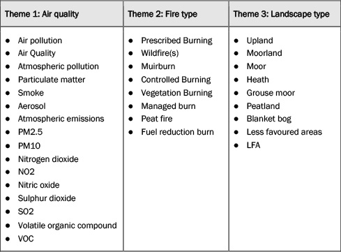
Note: Scopus search keywords used under each theme used to search the abstract, title and keywords of peer reviewed papers. The search was conducted to ensure that results included at least one keyword from each of the key themes.
The search (performed on 24 April 2025) returned a total of 131 papers, which were then screened for direct relevance to air quality. We excluded studies focusing only on indirect effects, such as ecosystem responses to air pollution. From this review, only three studies met our criteria: two studies on air quality impacts of the 2018 Saddleworth Moor wildfire (Graham et al., 2020a; Graham et al., 2020b) and one laboratory study on the characteristics of particles emitted from smouldering Irish peat (Wilson et al., 2025).
Our Rapid Systematic Review highlights a significant evidence gap in the UK and Ireland: no peer reviewed studies exist on air quality impacts from moorland management burning, despite its routine use in upland areas. A factor contributing to the lack of studies may be the short-lived and episodic nature of these fires, which makes them both difficult to monitor and model in relation to population exposure (UKHSA, 2023).
Among the pollutants emitted by vegetation fires, PM2.5 is the most widely studied, as it is a major component of smoke and is strongly linked to public health effects. Its composition however can vary due to combustion conditions and type of vegetation or peat being burned (Dong et al., 2020), which can influence both its toxicity and how it behaves in the atmosphere. In the UK context, an additional concern is the legacy of industrial pollution, which has left heavy metals and other pollutants deposited onto peatlands (Bonn et al., 2009). Vegetation fires can mobilise these legacy pollutants into the atmosphere, with uncertain but potential detrimental impacts on human and environmental health (McCarter et al., 2023).
In addition to PM2.5, it is also important to understand the contribution that moorland fires have on other air pollutants, such as nitrogen oxides, sulphur dioxide, and volatile organic compounds. When transported to urban areas, often within hours given the short distances between UK uplands and major cities, these pollutants can mix with existing urban emissions, altering local atmospheric chemistry and enhancing the formation of secondary air pollutants like surface ozone and SOA (Jaffe et al., 2020). This chemical mixing can lead to unexpected pollution episodes that are not well captured by air quality models or inventories and pose acute health risks to urban populations.
These concerns are important for the UK’s legal obligations under the Environment Act (2021) and the Environmental Targets (Fine Particulate Matter) (England) Regulations (2023), which required to reduce annual average PM2.5 concentrations to no more than 10 µg/m3 at any monitoring station by 2040, with population exposure at least 35 per cent lower than in 2018 (Environment Act 2021). The WHO (2021) guidelines also state that PM2.5 and NO2 should not exceed 15 µg/m3 and 25 µg/m3, respectively, over a 24-hour period.
Prescribed burning has the potential to contribute to short-term exceedances of these thresholds, particularly in regions downwind of burns. Despite this, it remains largely absent from emission inventories, air quality forecasting and public health planning. The combination of limited monitoring, inadequate regulation and increased fire risk under a warming climate underscores the urgent need for systematic research and policy attention on this overlooked source of regional air pollution.
Air quality impacts from three fire events in the Peak District National Park
The following three case studies from the Peak District National Park (PDNP) begin to illustrate the impacts of upland burning on air quality and suggest ways of addressing the knowledge gap identified in the previous section. Case study one is the Saddleworth Moor Wildfire which was studied extensively (Graham et al., 2020a; Graham et al., 2020b), and Case studies two and three are from prescribed burning events near Sheffield. The PDNP has a population of 36,000 and it is estimated 20 million people live within one hour’s journey, with the major cities of Sheffield and Manchester nearby (PDNPA, 2025). Given the proximity to large urban populations the Peak District represents an important location for studying the air quality impacts of upland fires.
Case study one: Saddleworth Moor wildfire (June-July 2018)
The Saddleworth Moor wildfire began on 24 June 2018 in northern England, near the towns of Stalybridge and Oldham in the Greater Manchester region. The fire, which was reported to have been started by a barbeque, burned through peat-rich moorland ecosystems, continuing intermittently for several weeks. Persistent underground smouldering contributed to prolonged emissions, and the event occurred during a period of unusually dry and warm weather, consistent with broader regional heatwave conditions (Graham et al., 2020b).
This event caused a substantial deterioration in regional air quality. Observations and modelling analyses showed that PM2.5 concentrations increased by 300-400 per cent in Manchester and surrounding areas, with daily means exceeding 50 µg/m³ – well above the WHO 24-hour guideline of 15 µg/m³ (Graham et al., 2020a). Air pollution was not confined to the immediate vicinity of the fire: more than 4.5 million people across northwest England were exposed to elevated PM2.5 levels during the peak burn period (23-30 June), including in cities such as Liverpool, Preston, and Warrington (Graham et al., 2020b).
Health impact assessments estimated a significant public health burden, with nine premature deaths attributable to the episode and an associated cost of £21.1 million to the UK’s health system and economy, accounting for both medical care and productivity losses (Graham et al., 2020b). This case study emphasises the critical need for improved visitor awareness about the environmental impacts of irresponsible fire use in upland areas, including disposable BBQs and other recreational burning.
Case study two: Prescribed burning near Sheffield (9 October 2023)
On 9 October 2023, a series of prescribed burns were conducted in the PDNP to the west of Sheffield. These fires occurred on a sunny, dry autumn day with moderate easterly winds, which carried smoke directly toward the urban area of Sheffield (Weber et al., 2023); they were routine land management practices associated with grouse moor management. They appear to comply with the relevant legislation at the time regarding burning in terms of timing and location.
The fires were geolocated using a combination of satellite imagery and geotagged photographs posted on social media (Weber et al., 2024), confirming active burning on moorland areas at Midhope Moor, Broomhead Estate, Strines Moor, and Hallam Moor. The episode lasted just under six hours, and it caused important spikes in PM2.5 concentrations in Sheffield (Figure 1). Hourly measurements from local air quality monitoring stations showed levels exceeding 40 µg/m³ for a period of approximately six hours, and a maximum hourly recording of 70 µg/m³ (Weber et al., 2023). However, because the event was brief, daily average PM2.5 concentrations did not surpass the WHO 24-hour guideline of 15 µg/m³.
Despite not triggering regulatory exceedances, the short-term intensity of this event posed a credible risk of exacerbating respiratory and cardiovascular conditions, particularly among sensitive populations. The absence of prior warning and the proximity of the fire source to a major urban area further highlight the gaps in monitoring, forecasting, and communication mechanisms surrounding prescribed burns. This event is important as it highlights, for the first time in academic literature, the significant negative air quality impacts on prescribed burning in the UK.
Figure 1: Hourly PM2.5 concentrations recorded on October 9th, 2023
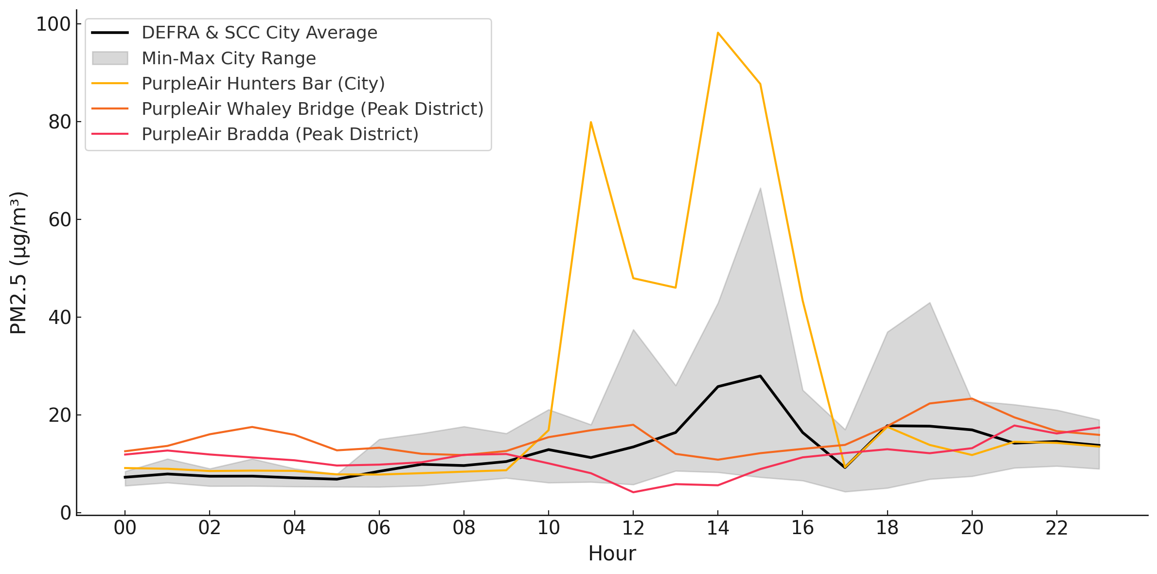
Note: PM2.5 concentrations recorded in Sheffield on October 9th, 2023. Shown are the hourly average, along with the minimum and maximum values, recorded across official monitoring sites operated by DEFRA and Sheffield City Council (Barnsley Road, Devonshire Green and Tinsley; Lowfield, Pond Hill, Wicker and Firvale). Also shown are PM2.5 recorded by Purpleair sensors located in Hunters Bar (Sheffield) and in the Peak District National Park (Bradda and Whaley Bridge).
Case study three: Prescribed burning on deep peat near Broomhead (11 and 13 November 2024)
On 11 and 13 November 2024 multiple prescribed burns were conducted in the PDNP around Broomhead. As part of our pilot project, FireUp, we deployed a network of ten particulate matter sensors across a subsection of the PDNP, Dark Peak Landscape Character Area in September and October 2024. The aim is to improve the detection of upland vegetation burning and assess associated air quality impacts. The sensors provide important real-time evidence of prescribed burning activity, and a detailed analysis of the sensor set-up and PM2.5 measurements will be reported separately.
On 11 November 2024 the sensor network picked up a prescribed burning event around Broomhead Moor (Figure 2). The event lasted six hours, a spike in PM2.5 levels downwind, towards a small residential area of the Peak District. As with Case Study Two, this highlights the acute air quality deterioration and potential risk on public health during the burning may have.
Figure 2: Hourly PM2.5 concentrations recorded on 11 November 2024
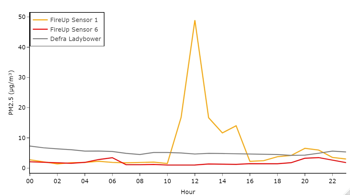
Note: Hourly PM2.5 measurements on 11 November 2024 recorded at the PDNP, upwind (FireUp Purpleair Sensor 6 and Defra monitoring site Ladybower) and downwind (FireUp Purpleair Sensor 1) of the burning event.
To enhance fire detection accuracy, periods of elevated PM2.5 concentrations from the air quality sensor data were triangulated with high-resolution satellite imagery from Planetscope and Sentinel-2 L1B data. Several events showed clear temporal and spatial alignment between PM2.5 spikes and visible prescribed burning captured in satellite imagery. Notably, three such events occurred in early November 2024 (Figure 3).
To assess potential regulatory implications, satellite-derived fire locations were imported into ArcPro and overlaid with the England Deep Peat Map, which delineates areas with peat depths of ≥40 cm as defined by Natural England. As shown in Figure 3, three burning incidents, one on 11 November and two on 13 November, were identified on designated deep peat, where prescribed burning is restricted or prohibited under existing environmental legislation (Natural England, 2021).
Figure 3: Map with burn events observed in November 2024
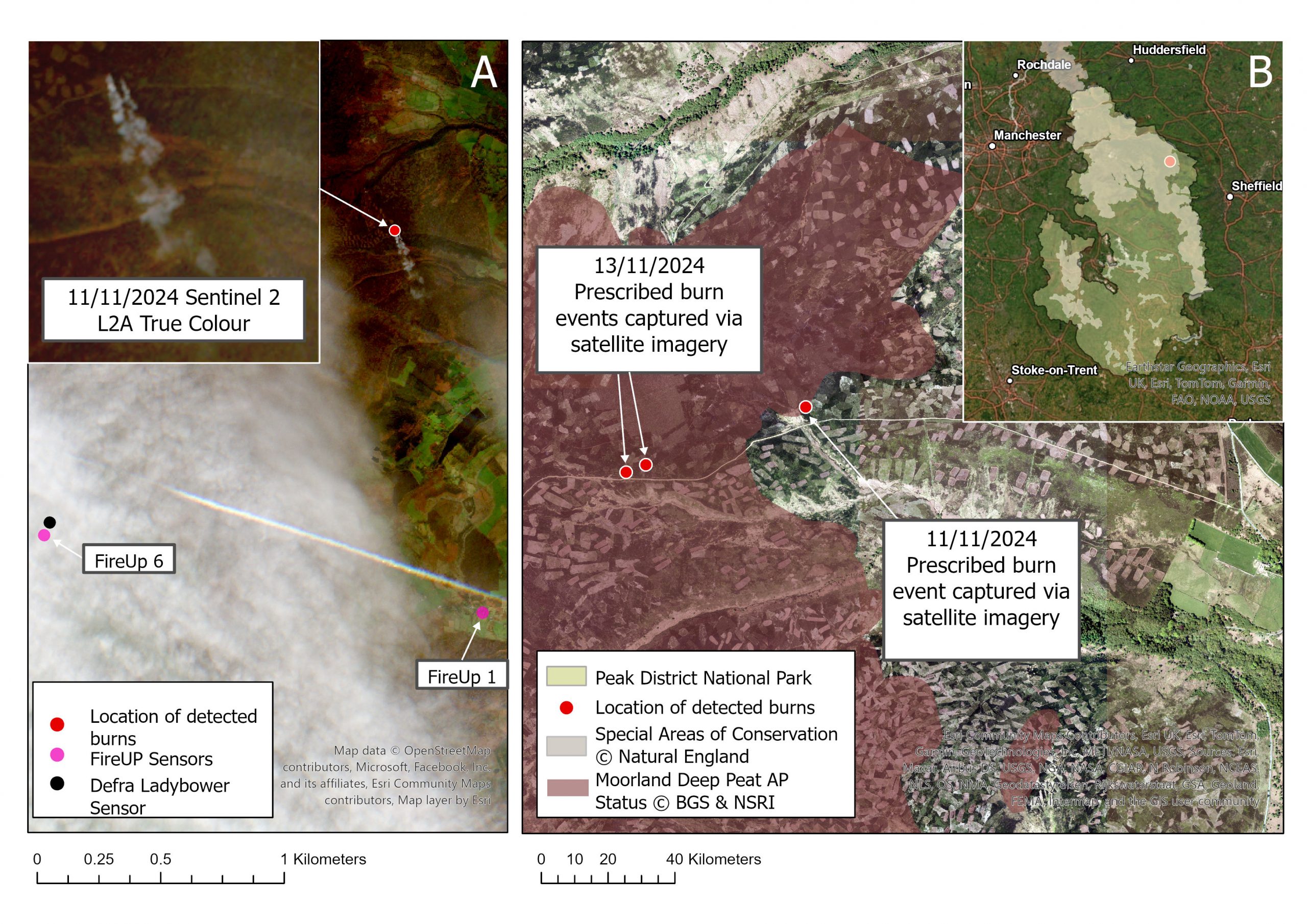
Note: = – A- Prescribed burning event captured via Copernicus Sentinel-2 data (2024), retrieved from Copernicus SciHub and processed by ESA (Left) with Fire Up Sensor location. B-Three prescribed burning events captured on Copernicus Sentinel-2 data (2024), retrieved from Copernicus SciHub and processed by ESA and Plantscope (2024) overlaid with Natural England Deep Peat Map (2024) based on peat >40cm depth. Inset map shows location of burning activity within the Peak District National Park and the South Pennine Moors Special Area of Conservation.
There is growing interest in the application of remote sensing for monitoring the extent, severity, and spatial distribution of prescribed burning in UK uplands. Recent studies have explored semi-automated detection methods using satellite data to map burn extent (Shewring et al., 2024; Spracklen & Spracklen, 2023) and assess fuel loads and wildfire risk (Szpakowski & Jensen, 2019).
Our case studies demonstrate the value of integrating ground-based sensor networks, satellite remote sensing, and geospatial analysis to enhance the detection of burning events and support regulatory enforcement. This mixed-methods approach provides a scalable and transparent framework for monitoring upland burning in protected landscapes.
The first case study illustrates how a single large-scale wildfire in UK peatlands can generate regionally significant air quality impacts with quantifiable consequences for public health. It underscores the importance of integrating wildland fire emissions into air quality monitoring and forecasting, health risk assessments, and emergency response planning. The second and third case studies demonstrate that even small-scale, routine moorland fires can cause acute air quality deterioration under specific meteorological conditions. They also underscore the potential for public health risks from prescribed burning to be systematically underestimated due to reliance on daily-averaged pollutant thresholds that obscure short-term peaks.
Advancing air quality understanding in upland regions through integrating sensors, satellites and communities
Air quality in the UK uplands remains poorly characterised, despite growing evidence that vegetation burning contributes to local and regional pollution. Existing monitoring networks are predominantly concentrated in urban centres and accessible lowland areas, leaving vast upland landscapes under-monitored. Figure 4 highlights this spatial disparity in monitoring coverage, showing the distribution of reference-grade stations (Defra AURN) and open-access low-cost sensors (PurpleAir and Sensor Community) around the Peak District National Park, as an example.
To understand these gaps, there is an urgent need for additional monitoring, integrating low-cost sensors such as the FireUp network, with remote sensing tools and citizen generated observations. Low-cost air quality sensors offer a scalable and flexible solution to address the lack of monitoring in remote regions, such as uplands. Although they are not regulatory grade in terms of precision or long-term stability, they provide valuable indicative data when deployed with appropriate quality control measures, such as collocations and periodic calibration (AQEG, 2023). Their affordability allows for denser networks that can detect localised smoke plumes and short-lived pollution events that would otherwise go unrecorded by the national network. The PurpleAir FireUp network has enabled an increase in spatial coverage around the PDNP moorland region. As shown in Figure 2, this denser monitoring network was able to detect a short-lived yet severe pollution spike during burning events in November 2024, which would otherwise be missed.
Low-cost sensor networks can also contribute to improving emissions inventories, especially for activities like prescribed burning that are often underestimated or excluded. They can also support real-time exposure estimates of pollution enabling public alerts and guide individuals to make informed decisions (Heydon et al., 2024), such as reducing outdoor activity during smoke events. Furthermore, these networks can provide a robust evidence base to inform actions for policy interventions and assess their effectiveness over time (AQEG, 2023).
Figure 4: Defra AURN sites and open access air quality sensor network around the PDNP
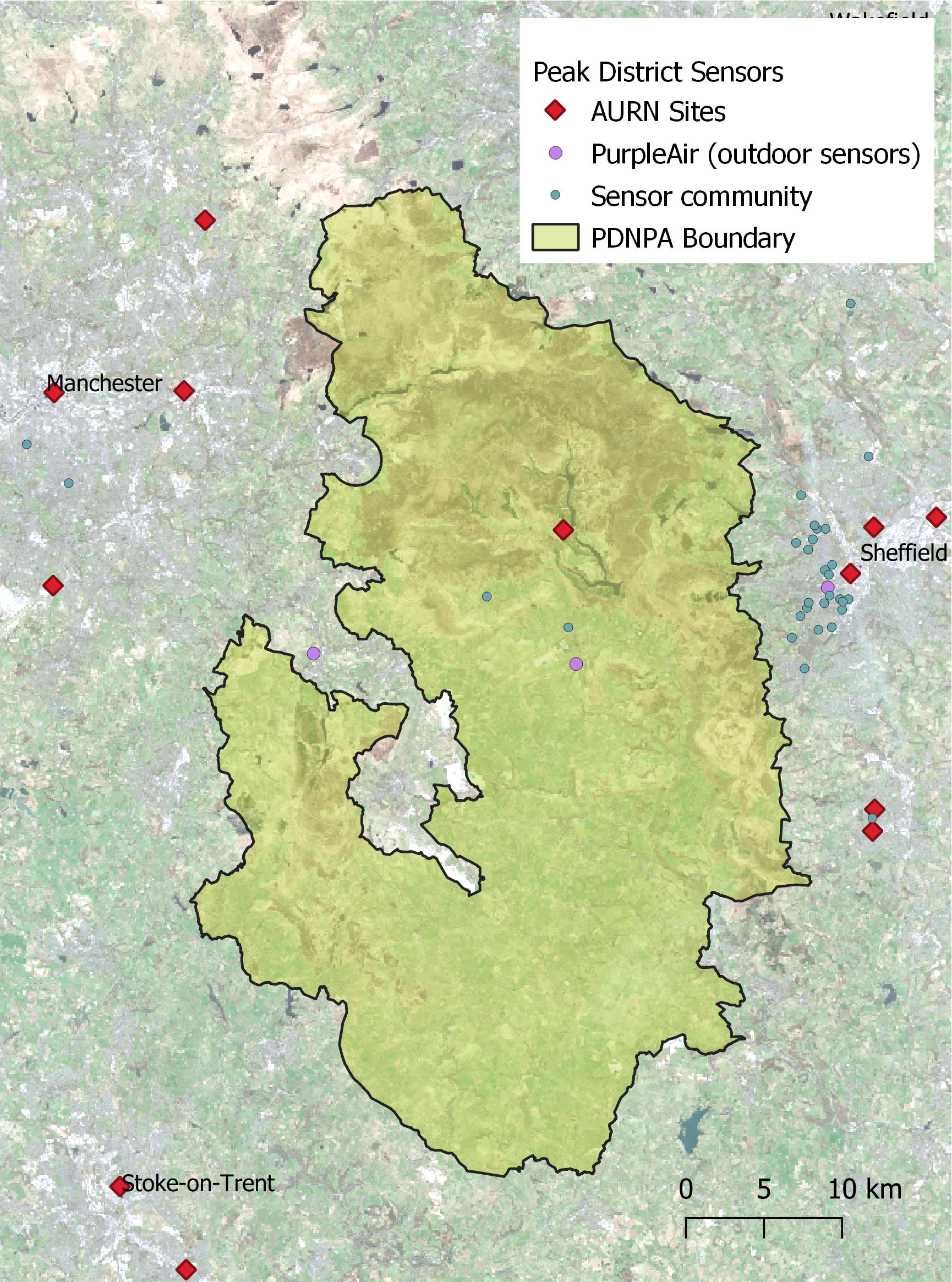
Note: The current Air Quality Monitoring Network around the Peak District National Park with the Defra Automatic Urban and Rural Network (AURN) sites and open access citizen science sites from PurpleAir and Sensor Community.
Globally, remote sensing data are used as an effective means of large-scale monitoring of wildfires, particularly in remote areas where ground monitoring is rare (Barber et al., 2024). Typically, satellite data can constrain the timing of burning, the area and rate of burning, and the smoke plume trajectory. At the same time, where access is possible, aerial photography and thermal imagery from Remotely Piloted Aircraft Systems (RPAS), can provide valuable data for both near real-time observation and post-fire assessment of burning events (Allison et al., 2016). During active fires, daily high-resolution satellite imagery (for example, 4m pixel size) can capture smoke plumes (for example, Case Study Three), fire fronts, and affected areas, providing visual documentation that complements ground-based observations (Hamilton et al., 2023). These data can be important records of events that can be used in combination with low-cost sensor networks to demonstrate causal relationships between burning events and air quality impacts. However, detection of wildfires using spaceborne optical data can be restricted by the repeat-interval of the satellite orbit (which can range from one to 16 days) and cloud coverage.
Nevertheless, if near-real time satellite data and ground monitoring are not available or possible, post-fire analysis of satellite-based imagery can also be an effective means of decoding the timing and impacts of wildfires and prescribed burning events. Indices such as the Normalized Burn Ratio (NBR) (Lees et al., 2021) can be effective for detecting burned vegetation and soil, delineating burn scars, and assessing burn severity (Labenski et al., 2024). These techniques use the spectral signatures of healthy versus burnt vegetation, allowing for detailed mapping of fire impacts across large and often remote areas. In addition, satellite data can be used to monitor vegetation recovery, soil degradation, and long-term landscape change (Lees et al., 2021), supporting ecological assessments and land management planning. Shewring et al. (2023) for instance, developed accurate, automated methods using Sentinel-2 imagery to map moorland burning across Great Britain, revealing spatial patterns and reductions linked to recent policy changes in England. In some cases, these data can be augmented by use of archival aerial photography (Allen et al., 2016) and RPAS data (Abdelmajeed et al., 2024).
One of the key challenges in upland monitoring is the vast expanse of remote and often inaccessible terrain that requires regular surveying to detect and assess the timing and impacts of wildfires and prescribed burning. While low-cost sensors provide unique ground-level data at key locations, they can often be more effective when integrated with satellite-based remote sensing to build a broader picture of fire activity and pollution dispersion (Weber et al., 2024). Remote sensing offers regional-scale coverage and information into the location, timing and extent of burns as well as smoke load, plume transport and altitude (Val Martin et al., 2013; 2018; Shewring et al., 2024). However, as noted, in the UK satellite observations are often hindered by frequent cloud cover and short fire durations (AQEG, 2023). These well-understood limitations make near real-time ground-based observations from sensor networks or citizen reports essential to enable comprehensive recording and reporting of wildfire and prescribed burning events, and to augment information not routinely recorded via satellite data.
A promising area of development is the integration of citizen science as a tool to enhance upland monitoring efforts (Staley et al., 2024). Citizen science can be broadly defined as the involvement of members of the public in the process of scientific research and monitoring (Pocock et al., 2017), and can include the contribution of a unique array of volunteered geographic information data (Florath et al., 2023).
In the context of upland burning, citizen science offers several key benefits. One of the most significant is its ability to improve event detection through increased geographic and temporal granularity of observations. Members of the public or civil society organisations can submit reports from areas that may otherwise be under-monitored. These time-stamped, ground-level observations are particularly valuable in contexts where remote sensing may fail to detect burn events. Additionally, they also assist in verifying measurements of burning emissions from ground-based sensors especially in cases where it may be difficult to distinguish between other pollutant sources. By contributing location-specific data on burning in remote areas, citizen observations can fill geographical and temporal gaps, improving the consistency and reliability of fire monitoring datasets.
The utility of such contributions is exemplified by the two successful prosecutions for illegal burning on deep peat since the introduction of the Heather and Grass etc. Burning (England) Regulations 2021. In the first case, a landowner was prosecuted for burning across 46 hectares of deep peat on Midhope Moor in the Peak District (Baynes, 2023). This case was triggered by observations submitted by an RSPB conservation officer, who reported the burns to Defra using photographic and video evidence. In the second case, the landowner of Middlesmoor Estate in Nidderdale was convicted following a report similarly submitted to Defra (Tate, 2023). The rarity of such convictions is symptomatic of the difficulties in detecting burning in such remote areas, but these cases demonstrate how data generated through citizen science can play a vital role in enforcement, particularly where regulatory agencies have limited capacity for routine, on-the-ground inspection.
Beyond its technical advantages, citizen science may also foster stronger local stewardship of upland landscapes (Day et al., 2022). Engagement in monitoring activities can increase public awareness, enhance place-based knowledge, and promote community involvement in sustainable land management practices (Appenfeller, et al., 2020). In this way, citizen science contributes not only to improved environmental governance, but also to the cultivation of social responsibility for the long-term health of upland ecosystems.
Triangulating data from air quality sensors, remote sensing, and citizen science provides a more comprehensive assessment of burn events. The integration of these techniques also allows rapid data collection during or immediately after burn events, which is essential for assessing fire severity, acute air quality impacts, ecological damage, and evidencing breaches of land-use regulation. In the longer term, this approach could support the development of an early warning system for air quality impacts of fires, improving public health responses.
Policy and Research Implications
In recent years, regulatory efforts to restrict burning on peatland have intensified, as noted above. Proposed amendments in 2025 aim to strengthen these provisions by lowering the peat depth threshold which will increase the area covered from 222,000 hectares to around 368,000 hectares of upland deep peat, with a new ‘deep peat map’ being developed to reflect these changes (Defra, 2025). Additionally, the revised regulations are expected to reduce exemptions and licensing allowances, thereby extending the scope of peatland protection.
However, as regulatory requirements grow more stringent, their success increasingly hinges on the capacity for enforcement. Peatland burning often occurs in remote upland areas, where oversight is limited, activities difficult to detect, and gathering actionable evidence is challenging. In this context, regulatory effectiveness will depend not only on legal prohibitions but also on effective enforcement mechanisms, particularly detection and evidence gathering strategies. This is especially concerning given that the budget for environmental monitoring and enforcement by organisations such as Natural England has been declining significantly over the past decade (Natural England, 2020).
Without robust enforcement capacity, there is a risk that these regulations will amount to ‘performative governance,’ which mixes symbolic gestures with a lack of substantive action (Lees & Pederson, 2024, p. 125). In the case of peatland burning, this risk is particularly acute. The activity tends to occur out of sight, and its environmental consequences are diffuse and delayed, while enforcement bodies are constrained by limited resources and geographical reach. Indeed, successful prosecutions for illegal peatland burning have been exceptionally rare. While this may indicate widespread landowner adherence with the 2021 burning regulations (Beeson, 2022), satellite evidence collected and analysed by NGOs suggests a greater degree of non-compliance (Howard & Dowler, 2022).
The 2025 proposals for expanding the regulatory framework may inadvertently exacerbate this issue. By extending coverage to more remote and less monitored areas detection may become even more difficult, widening the enforcement gap. While the expansion of protected areas represents an important step towards environmental conservation, it brings with it greater regulatory responsibility. However, without concurrent investment in detection technologies, monitoring frameworks, and local stakeholder engagement, the effectiveness of these new protections is likely to remain constrained.
Avoiding this situation will require the use of modern technologies, including air quality sensor networks, satellite data, and community-based reporting systems to support evidence gathering, ensure consistent enforcement responses, and foster trust among land managers and the public. These technologies will be essential to ensure enforcement is not only visible but also capable of addressing the complex challenges associated with peatland burning.
In support of this approach, a recent independent review of the UK’s environmental regulators, commissioned by the Secretary of State, called for more consistent monitoring and enforcement to enhance public trust in environmental regulations. The review recommended that the ‘probability of being caught… needs to increase’ and ‘not least through the use of technology’ (Corry, 2025, p. 42). This underscores the need for innovative enforcement strategies to meet the objectives of the 2025 proposals.
In this context, the development of a combined citizen science air quality system as proposed in this paper, could play a critical role in enhancing enforcement capacity. By integrating community-based monitoring with advanced technologies, such a system would provide a scalable, cost-effective solution for improving detection and evidence gathering, ultimately supporting more effective regulatory enforcement and contributing to the long-term success of peatland protection.
Concluding remarks
Wildfires and prescribed burning are globally significant environmental issues, impacting biodiversity, air quality, and land management across a wide range of ecosystems (Bowman & Sharples, 2023). In the UK, the impacts of upland fires on air quality are often overlooked despite their potential to cause substantial degradation and pose significant public health risks.
Monitoring technologies that integrate multiple data sources, such as ground-based sensors, remote sensing, and citizen science, offer scalable, cost-effective and adaptable tools for tracking fire events in real time in remote or under-monitored areas. These integrated methods enhance fire detection and responses, as well as enable more accurate estimates of atmospheric emissions from upland fires which are currently underestimated or absent from emissions inventories. Through informing evidence-based policy decision making and improving the accountability of land management practices these approaches form an effective strategy to support the implementation of sustainable land-use practices worldwide.
Policy and legislation should take into consideration the significant impacts on air quality and provide adequate resources to monitor the impacts described in this paper. Future work is needed to refine these approaches in the UK uplands, improving emissions quantification of upland fires and develop early fire warning systems which would be applicable to both prescribed burning and uncontrolled wildfires.
MVM acknowledges funding from the UKRI Future Leaders Fellowship Programme (MR/T019867/1). RB & JG acknowledges Sheffield Hallam University for FireUp funding and volunteers hosting the FireUp sensors. We thank James Weber and James King for their published analysis of the October 2023 prescribed burn event, which informed Case Study Two.
Dr Rebecca Brownlow and Dr Joe Glentworth, City Campus, Howard Street, Sheffield, S1 1WB, UK. Email: r.brownlow@shu.ac.uk / j.w.glentworth@shu.ac.uk
Abdelmajeed, A.Y.A., & Juszczak, R. (2024). Challenges and limitations of remote sensing applications in northern peatlands: present and future prospects. Remote Sensing, 16(3), p.591. CrossRef link
Ainsworth, E. A., Yendrek, C. R., Sitch, S., Collins, W. J., Emberson, L. D., & Merchant, S. S. (2012). The effects of tropospheric ozone on net primary productivity and implications for climate change. Annual Review of Plant Biology, 63(1), 637-661. CrossRef link
Air Quality Expert Group (AQEG) (2023). New Opportunities for Particulate Measurements. Defra Air Quality Expert Group. https://uk-air.defra.gov.uk/assets/documents/reports/cat05/2411120859_PM_measurement_AQEG_submitted_19jun2023_update20241111.pdf
Allison, R. S., Johnston, J. M., Craig, G., & Jennings, S. (2016). Airborne optical and thermal remote sensing for wildfire detection and monitoring. Sensors, 16(8), 1310. CrossRef link
Allen, K.A., Denelle, P., Ruiz, F.M.S., Santana, V.M., & Marrs, R.H., (2016). Prescribed moorland burning meets good practice guidelines: a monitoring case study using aerial photography in the Peak District, UK. Ecological Indicators, 62, pp.76-85. CrossRef link
Andreae, M. O. (2019). Emission of trace gases and aerosols from biomass burning – an updated assessment. Atmospheric Chemistry and Physics, 19(13), 8523-8546. CrossRef link
Appenfeller, L. R., Lloyd, S., & Szendrei, Z. (2020). Citizen science improves our understanding of the impact of soil management on wild pollinator abundance in agroecosystems. PloS One, 15(3), e0230007. CrossRef link
Ashby, M. A., & Heinemeyer, A. (2021). A critical review of the IUCN UK peatland programme’s “burning and peatlands” position statement. Wetlands, 41(56). CrossRef link
Barber, Q.E., Jain, P., Whitman, E., Thompson, D.K., Guindon, L., Parks, S.A., Wang, X., Hethcoat, M.G., & Parisien, M.A., (2024). The Canadian fire spread dataset. Scientific data, 11(764). CrossRef link
Baynes, C. (2023, May 11). Peak district landowner admits illegal peat burning on moorland. BBC News. https://www.bbc.co.uk/news/uk-england-south-yorkshire-65554705
Beeson, R. (2022, May 31). Heather burning – presenting the true picture. moorland association. Moorlands Association. https://www.moorlandassociation.org/post/heather-burning-presenting-the-true-picture
Bonn, A., Allott, T., Hubacek, K., & Stewart, J. (2009). Drivers of environmental change in uplands. Routledge, Oxon.
Bowman, D. M. J. S., Kolden, C. A., Abatzoglou, J. T., Johnston, F. H., van der Werf, G. R., & Flannigan, M. (2020). Vegetation fires in the Anthropocene. Nature Reviews. Earth & Environment, 1(10), 500-515. CrossRef link
Bowman, D. M. J. S., & Sharples, J. J. (2023). Taming the flame, from local to global extreme wildfires. Science (American Association for the Advancement of Science), 381(6658), 616–619. CrossRef link
Caseldine, C., & Hatton, J. (1993). The development of high moorland on Dartmoor: Fire and the influence of Mesolithic activity on vegetation change In Chambers, F.M. (eds), Climate change and human impact on the landscape (pp. 119-131). Springer Netherlands. CrossRef link
Climate Change Committee (2020). Land Use: Policies for a Net Zero UK. https://www.theccc.org.uk/wp-content/uploads/2020/01/Land-use-Policies-for-a-Net-Zero-UK.pdf
Climate Change Committee (2025). The Seventh Carbon Budget. https://www.theccc.org.uk/publication/the-seventh-carbon-budget/
Corry, D. (2025). Delivering economic growth and nature recovery: An independent review of Defra’s regulatory landscape. https://assets.publishing.service.gov.uk/media/67ef87e9e9c76fa33048c7a9/dan-corry-review-defra-regulatory-landscape.pdf
Crutzen, P.J., & Andreae, M. O. (1990). Biomass burning in the tropics: Impact on atmospheric chemistry and biogeochemical cycles. Science, 250(4988), 1669-1678. CrossRef link
Davies, G. M., Vandvik, V., Marrs, R., & Velle, L. G. (2022). Fire management in heather-dominated heaths and moorlands of north-west Europe. In J.R. Weir & D Scasta (eds), Global application of prescribed fire . CSIRO Publishing.
Davies, G. M., Kettridge, N., Stoof, C. R., Gray, A., Marrs, R., Ascoli, D., Fernandes, P. M., Allen, K. A., Doerr, S. H., Clay, G. D., McMorrow, J., & Vandvik, V. (2016). The peatland vegetation burning debate: Keep scientific critique in perspective. A response to Brown et al. and Douglas et al. Philosophical Transactions of the Royal Society of London. Series B. Biological Sciences, 371(1708), 20160434. CrossRef link
Day, G., Fuller, R. A., Nichols, C., & Dean, A. J. (2022). Characteristics of immersive citizen science experiences that drive conservation engagement. People and Nature, 4(4), 983-995. CrossRef link
Department for Environment, Food & Rural Affairs (Defra) (2025). Heather and grass burning in England: Consultation document. https://consult.defra.gov.uk/peatland-protection-team/heather-and-grass-burning-in-england/supporting_documents/Heather%20and%20Grass%20Burning%20Consultation%20Document.pdf
Dodgshon, R. A., & Olsson, G. A. (2006). Heather moorland in the Scottish Highlands: The history of a cultural landscape, 1600-1880. Journal of Historical Geography, 32(1), 21-37. CrossRef link
Done, A., & Muir, R. (2008). The landscape history of grouse shooting in the Yorkshire Dales. Rural History, 12(2), 195-210. CrossRef link
Dong, T. T. T., Stock, W. D., Callan, A. C., Strandberg, B., & Hinwood, A. L. (2020). Emission factors and composition of PM2.5 from laboratory combustion of five western Australian vegetation types. The Science of the Total Environment, 703, 134796. CrossRef link
Fann, N., Alman, B., Broome, R. A., Morgan, G. G., Johnston, F. H., Pouliot, G., & Rappold, A. G. (2018). The health impacts and economic value of wildland fire episodes in the U.S.: 2008–2012. The Science of the Total Environment, 610-611, 802-809. CrossRef link
Florath, J., Chanussot, J., & Keller, S. (2023). Utilizing volunteered geographic information for real-time analysis of fire hazards: Investigating the potential of Twitter data in assessing the impacted areas. Fire, 7(1), 6. CrossRef link
Gilchrist, A., Glentworth, J., Hairul Sharani Mohd Radzuan, & Clay, G. D. (2024). The influence of recreational activity on upland ecosystems in the UK: A review of evidence. The University of Manchester.
Gimingham, C. H. (1970). British heathland ecosystems: The outcome of many years of management by fire. Proceedings: 10th Tall Timbers Fire Ecology Conference 1970.
Glaves, D., Haycock, N. E., Costigan, P., Coulson, J. C., R. H. Marrs, Robertson, P. A., & Younger, J. (2005). Defra review of the heather and grass burning regulations and code: Science panel assessment of the effects of burning on biodiversity, soils and hydrology. Independent Science Panel report to Defra. CrossRef link
Glaves, D., Morecroft, M., Fitzgibbon, C., Owen, M., Phillips, S., & Leppitt, P. (2013). The effects of managed burning on upland peatland biodiversity, carbon and water (NEER004). Natural England.
Glentworth, J. W. (2022). Can Rewilding Work for Everyone?: Navigating Actor Perspectives Towards Upland Rewilding [Doctoral dissertation, The University of Manchester (United Kingdom)].
Graham, A. M., Pope, R. J., McQuaid, J. B., Pringle, K. P., Arnold, S. R., Bruno, A. G., Moore, D. P., Harrison, J. J., Chipperfield, M. P., Rigby, R., Sanchez-Marroquin, A., Lee, J., Wilde, S., Siddans, R., Kerridge, B. J., Ventress, L. J., & Latter, B. G. (2020a). Impact of the June 2018 Saddleworth moor wildfires on air quality in northern England. Environmental Research Communications, 2(3), 31001. CrossRef link
Graham, A.M., Pope, R.J., Pringle, K.P., Arnold, S., Chipperfield, M.P., Conibear, L.A., Butt, E.W., Kiely, L., Knote, C., & McQuaid, J.B. (2020b). Impact on air quality and health due to the Saddleworth moor fire in northern England. Environmental Research Letters, 15(7), 74018. CrossRef link
Hamilton, D., Gibson, W., Harris, D., & McGath, C. (2023). Evaluation of Multi-Spectral Band Efficacy for Mapping Wildland Fire Burn Severity from PlanetScope Imagery. Remote Sensing, 15(21), p.5196. CrossRef link
Heydon, J., Chakraborty, R., Patel, V., Wood, C., Wood, M., & Bunce, C. (2024). Reconceiving domestic burning controls: Air quality alerts, behavioural responsive regulation, and designing for compliance. Environmental Management, CrossRef link
Holland, J. P., Pollock, M., Buckingham, S., Glendinning, J., & McCracken, D. (2022). NatureScot Research Report 1302-Reviewing, assessing and critiquing the evidence base on the impacts of muirburn on wildfire prevention, carbon storage and biodiversity.
Howard, E., & Dowler, C. (2022). Satellites reveal widespread burning on England’s protected peatlands, despite government ban. Unearthed. https://unearthed.greenpeace.org/2022/05/30/satellites-fires-burning-england-peatland-grouse-shooting/
Jaffe, D. A., O’Neill, S. M., Larkin, N. K., Holder, A. L., Peterson, D. L., Halofsky, J. E., & Rappold, A. G. (2020). Wildfire and prescribed burning impacts on air quality in the United States. Journal of the Air & Waste Management Association, 70(6), 583-615. CrossRef link
Jepson, P. (2016). A Rewilding agenda for Europe: Creating a network of experimental reserves. Ecography, 39(2). CrossRef link
Labenski, P., Millin-Chalabi, G., Pacheco-Pascagaza, A.M., Senn, J.A., Fassnacht, F.E., & Clay, G.D. (2024). An optical satellite-based analysis of phenology and post-fire vegetation recovery in UK upland moorlands. Environmental and Sustainability Indicators, 24, 100492. CrossRef link
Langmann, B., Duncan, B., Textor, C., Trentmann, J., & van der Werf, G. R. (2009). Vegetation fire emissions and their impact on air pollution and climate. Atmospheric Environment (1994), 43(1), 107-116. CrossRef link
Lauk, C., & Erb, KH. (2016). A Burning Issue: Anthropogenic Vegetation Fires. In H. Haberl, M. Fischer-Kowalski, F. Krausmann, & V. Winiwarter (eds), Social Ecology. Human-Environment Interactions, Vol 5. Springer, Cham. CrossRef link
Lees, K.J., Buxton, J., Boulton, C.A., Abrams, J.F., & Lenton, T.M. (2021). Using satellite data to assess management frequency and rate of regeneration on heather moorlands in England as a resilience indicator. Environmental Research Communications, 3(8), 085003. CrossRef link
Lees, E., & Pedersen, O. (2024). Performative Environmental Law. Modern Law Review, 88(1), 124-154. CrossRef link
Legg, C. J., Maltby, E., & Proctor, M. C. F. (1992). Ecology of severe moorland fire on the North York Moors: Seed distribution and seedling establishment of Calluna Vulgaris. The Journal of Ecology, 80(4), 737-752. CrossRef link
McCarter, C. P. R., Clay, G. D., Wilkinson, S. L., Page, S., Shuttleworth, E. L., Davidson, S. J., Taufik, M., Sigmund, G., & Waddington, J. M. (2023). Peat fires and the unknown risk of legacy metal and metalloid pollution. Environmental Research Letters, 18(7), 71003. CrossRef link
Meredith, J. (1986). Protecting special landscapes – the wildlife and countryside acts and national parks. Landscape Research, 11(3), 24–27. CrossRef link
Natural England. (2020). Correspondence from Dr Tony Juniper CBE to the Phillip Dunne MP Chair of the Environmental Audit Select Committee. UK Parliament Committees. https://committees.parliament.uk/publications/3453/documents/32928/default/
Noble, A., Palmer, S. M., Glaves, D. J., Crowle, A., Brown, L. E., & Holden, J. (2017). Prescribed burning, atmospheric pollution and grazing effects on peatland vegetation composition. The Journal of Applied Ecology, 55(2), 559-569. CrossRef link
Noble, A., Glaves, D.J., Leppitt, P., Crowle, A., Key, D., & Rodgers, A. (2025). An evidence review update on the effects of managed burning on upland peatland biodiversity, carbon and water. Natural England Evidence Review, NEER155. Natural England.
Paul, MJ, LeDuc, SD, Boaggio, K, Herrick, J.D., Kaylor, S.D., Lassiter, M.G., Nolte, C.G., & Rice, R.B. (2023). Effects of Air Pollutants from Wildfires on Downwind Ecosystems: Observations, Knowledge Gaps, and Questions for Assessing Risk. Environmental Science & Technology, 57(40), 14787-14796. CrossRef link
PDNPA (2025). Media Centre Facts and Figures. Peak District National Park. https://www.peakdistrict.gov.uk/learning-about/news/mediacentrefacts
Pocock, M. J. O., Tweddle, J. C., Savage, J., Robinson, L. D., & Roy, H. E. (2017). The diversity and evolution of ecological and environmental citizen science. Plos One, 12(4), e0–e0172579. CrossRef link
Public Health England (2018). Health matters: air pollution. https://www.gov.uk/government/publications/health-matters-air-pollution/health-matters-air-pollution
Shewring, M. P., Wilkinson, N. I., Teuten, E. L., Buchanan, G. M., Thompson, P., & Douglas, D. J. T. (2024). Annual extent of prescribed burning on moorland in Great Britain and overlap with ecosystem services. Remote Sensing in Ecology and Conservation, 10(5), 597-614. CrossRef link
Simmons, I. G. (1996). The environmental impact of later Mesolithic cultures: The creation of moorland landscape in England and Wales. Edinburgh University Press.
Spracklen, B. D., & Spracklen, D. V. (2023). Assessment of peatland burning in Scotland during 1985–2022 using Landsat imagery. Ecological Solutions and Evidence, 4(4). CrossRef link
Staley, J., McCracken, M., & Pocock, M. (2024). Evaluating the current state and potential of citizen science involving farmers. Natural England Commissioned Report NECR583. Natural England.
Szpakowski, D., & Jensen, J. (2019). A review of the applications of remote sensing in fire ecology. Remote Sensing, 11(22), 2638. CrossRef link
Tate, L. (2023, October 23). Landowner admits to illegal burning of peat in Nidderdale SSSI. Craven Herald and Pioneer. https://www.cravenherald.co.uk/news/23872760.landowner-admits-illegal-burning-peat-nidderdale-sssi/
Thompson, D. B. A., MacDonald, A. J., Marsden, J. H., & Galbraith, C. A. (1995). Upland heather moorland in Great Britain: A review of international importance, vegetation change and some objectives for nature conservation. Biological Conservation, 71(2), 163-178. CrossRef link
Thompson, D. B. A., & Horsfield, D. (1997). Upland habitat conservation in Scotland: a review of progress and some proposals for action. Botanical Journal of Scotland, 49(2), 501-516. CrossRef link
Thompson, P. S., Douglas, D. J. T., Hoccom, D. G., Knott, J., Roos, S., & Wilson, J. D. (2016, April). Environmental impacts of high-output driven shooting of red grouse lagopus lagopus scotica International Journal of Avian Science, 158(2), 446-452. CrossRef link
Tricco, A. C., Antony, J., Zarin, W., Strifler, L., Ghassemi, M., Ivory, J., Perrier, L., Hutton, B., Moher, D., & Straus, S. E. (2015). A scoping review of rapid review methods. BMC Medicine, 13(1), 224. CrossRef link
UKHSA (2023). Health Effects of Climate Change (HECC) in the UK: 2023 report, Chapter 10: Wildfires and health. https://assets.publishing.service.gov.uk/media/65705b7a7391350013b03bbc/HECC-report-2023-chapter-10-wildfires.pdf
Val Martin, M., Heald, C.L., Ford, B., Prenni, A.J., & Wiedinmyer, C. (2013). A decadal satellite analysis of the origins and impacts of smoke in Colorado, Atmos. Chem. Phys, 13, 7429-7439. CrossRef link
Val Martin, M., Kahn, R. A., & Tosca, M. G. (2018). A global analysis of wildfire smoke injection heights derived from space-based multi-angle imaging. Remote Sensing, 10(10), 1609. CrossRef link
Weber, J., Val Martin, M., & Bryant, R. (2023). Impact of Moorland Fires on Sheffield Air Quality on 9th October 2023. The University of Sheffield. https://doi.org/10.15131/shef.data.24356629.v1
Weber, J., King, J., Bryant, R., & Val Martin, M. (2024). Sheffield Moorland Burning 9th and 17th October 2023: Fire Locations, Pollution Dispersion and Air Quality. The University of Sheffield. https://doi.org/10.15131/shef.data.25145576.v1
WHO (2021). What are the WHO Air quality guidelines? World Health Organisation. https://www.who.int/news-room/feature-stories/detail/what-are-the-who-air-quality-guidelines
Wilson, A. L., Cui, W., Hu, Y., Chiapasco, M., Rein, G., Porter, A. E., Fowler, G., & Stettler, M. E. J. (2025). Particles emitted from smouldering peat: Size-resolved composition and emission factors. Environmental Science: Atmospheres, 5(3), 348-366. CrossRef link
Worrall, F., Clay, G.D., Marrs, R., & Reed, M.S. (2010). Impacts of Burning Management on Peatlands. IUCN Technical Review.
Yallop, A.R., & Clutterbuck, B. (2009). Burning issues: The history and ecology of managed fires in the uplands. In A Bonn, T Allott, K Hubacek & J Stewart (eds), Drivers of environmental change in uplands (pp. 199-213). Routledge.
Zhu, J., & Liu, W. (2020). A tale of two databases: The use of web of science and Scopus in academic papers. Scientometrics, 123(1), 321-335. CrossRef link